 Tweet
Tweet
I thought I'd put together a list of tools and the types of maps that can be used with each.
:arrow: OziExplorer
Windows only map tool for Raster based maps and supports waypoints, tracks and routes. Can communicate with specific GPS devices. Does not support turn by turn navigation
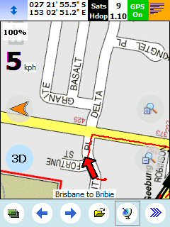
:arrow: OziExplorer CE
Windows CE version of the above tool with customisable interface. Only supports Raster based maps and requires registration key ($40.00)
OziExplorer CE Screen Designer

:arrow: GIS Russa
Licensed tool to display vector based Garmin style maps. Assume that, like Ozi, this does not support turn by turn but does support waypoints, routes and tracks

:arrow: GPSVP
Freeware tool for running on Windows, PacketPC and Smartphone that for Raster and Vector (Garmin style .img maps) maps. Very basic interface.
:arrow: More and More GPS Tools (There is a lot of goodies out there)
To go with this you need some maps. Plenty of good detail in other threads but worthwhile looking in:
:arrow: Free Topographic Maps (Pradopoint.com) (Raster maps sourced from Geoscience Australia)
:arrow: Shonkymaps (Donwload site)
:arrow: Shonkymaps (Pradopoint.com) (Garmin style vector maps and includes details on Contours Australia and Open Street maps but not Tracks4Australia)
:arrow: Garmin GPS Map Search
Did a quick search on a collection like this but didn't find much. Will add more to this later
:arrow: OziExplorer
Windows only map tool for Raster based maps and supports waypoints, tracks and routes. Can communicate with specific GPS devices. Does not support turn by turn navigation
:arrow: OziExplorer CE
Windows CE version of the above tool with customisable interface. Only supports Raster based maps and requires registration key ($40.00)
OziExplorer CE Screen Designer
:arrow: GIS Russa
Licensed tool to display vector based Garmin style maps. Assume that, like Ozi, this does not support turn by turn but does support waypoints, routes and tracks
:arrow: GPSVP
Freeware tool for running on Windows, PacketPC and Smartphone that for Raster and Vector (Garmin style .img maps) maps. Very basic interface.
:arrow: More and More GPS Tools (There is a lot of goodies out there)
To go with this you need some maps. Plenty of good detail in other threads but worthwhile looking in:
:arrow: Free Topographic Maps (Pradopoint.com) (Raster maps sourced from Geoscience Australia)
:arrow: Shonkymaps (Donwload site)
:arrow: Shonkymaps (Pradopoint.com) (Garmin style vector maps and includes details on Contours Australia and Open Street maps but not Tracks4Australia)
:arrow: Garmin GPS Map Search
Did a quick search on a collection like this but didn't find much. Will add more to this later
Comment